.png)
Early Greenland Melt
 |
| Greenland melt pond. Credit: Michael Studinger, NASA GSFC, 2008 |
Hot in the North
So far April has been amazingly warm, today I had to water my plants due to lack of rain. It's probably the first time I had to water outside so early in the spring. There have even been warnings about the risk for grass fires.
If it's this hot at 60°N one has to wonder how the Arctic is faring. According to the Arctic Sea Ice Blog Greenland experienced an early melt event this Monday, with 12% of the ice sheet that had more than 1 mm of melt. Greenland’s usual melt season runs from early June to September. Looking at the graph below I realize how extreme that event was.
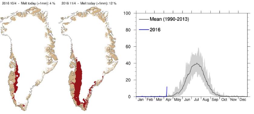 |
| Maps showing areas where melting took place on the 10-11th April. Graph shows standard deviation - percentage of total area where melting occurred. Source: DMI, 2016 |
According to the Danish Meteorological Institute the melt was driven by warm air coming in from the southwest, bringing rain along the coast, similar to what happened in 2012 when later on there was an extreme melt event, 95% of the surface of the ice sheet melted.
Melting ice at the poles is already causing a slowdown of the Atlantic meridional overturning circulation that transfers heat from the tropics to the North Atlantic. The cold blob from freshwater runoff below Greenland is also a source of major storms in the North Atlantic as warm weather crashes with the unusually cold. This has impacts on people's livelihoods in Northern Europe and the US East Coast.
Depending on the doubling time, the amount of time it would take for ice loss from the ice sheets to double, say if it's as short as 10 or 20 years like Hansen has proposed we could come to see several meters of sea level rise already by 2050. Perhaps its not likely but its possible.


0 kommentarer: