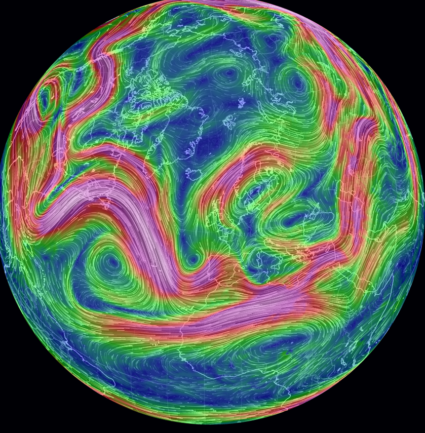
Jet streams consists of bands of very strong winds which move weather systems around the globe. These have been relatively stable until recently due to a decrease in temperature gradient between the equator and north pole. Below is a satellite image of a mangled jet stream, using Earth Nullschool, creating blocking patterns that makes weather system seem “stuck”. For example, here in southeast Sweden we are experiencing record warm May temperatures (20-25 C), little rain or wind with a high risk of forest fires.
Jet stream pattern over Europe, with warm air “stuck” over Scandinavia
.
A similar situation but much worse is occurring in Canada where massive forest fires have driven 88,000 canadians out of their homes in Fort McMurray. These people are now climate refugees and more damage is yet to come as the fire is now moving towards Alberta’s tar sand fields and could double in size due to strong winds and dry conditions. The fire cover an area as large as Hong Kong.
.
Melting Arctic sea ice causes more heat to be absorbed by the darker surface of the ocean, especially in late spring when the sun is really strong. The extra heat is then also transferred into the atmosphere. When this happens the lower layers of the atmosphere warms and expand, pushing up the higher layers and causing the jet stream to bulge. As the sea ice disappears and the atmosphere in the Arctic warms the airflow in the jet stream is more likely to loop and bulge, causing blocking events.
“High pressure systems over Greenland can have the effect of blocking polar jet stream flow over part of the North Atlantic […] causing the jet stream to split into branches and bringing about all kinds of severe weather events as a result.” according to Dr. Edward Hanna from the University of Sheffield.
Researchers are worried that these type of blocking events of high pressure systems over Greenland can lead to rapid melt of the ice sheet as well as causing extreme weather events over the northern hemisphere.
Changes in Atlantic Ocean circulation worries scientists
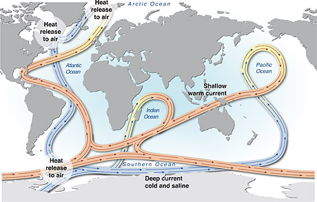
The risk of abrupt and/or irreversible climate change is determined by a crossing of tipping elements in the Earth system. One such tipping element is the North-South ocean current circulation in the Atlantic Ocean, also known as the Gulf Stream system. The Gulf Stream system is one of Earth’s most important heat transport systems, pumping warm water northwards and cold water southwards. It is responsible for the mild climate in northwestern Europe and the most important source of heat transport to Scandinavia.
A potential abrupt change, or slowing down of the Gulf Stream circulation could lead to a weakening of heat transportation towards the Arctic which in turn would result in a cooling effect of high northern latitudes (including Scandinavia).
Scientists at Potsdam University have now found evidence for a slowdown of the Gulf Stream (published in Nature). Multiple lines of observation suggest that in recent decades the current system has been weaker than ever before in the last 1000 years. The gradual but accelerating melting of the Greenland ice-sheet, caused by man-made global warming, is a possible major contributor to the slowdown.
The blue cooling spot south of Greenland: NASA GISS warming map 1901-2013. Source: PIK-Potsdam
“Now freshwater coming off the melting Greenland ice sheet is likely disturbing the circulation”, saysJason Box of the Geological Survey of Denmark and Greenland. The melting glaciers are diluting the North Atlantic ocean salty water. Less salty water is less dense and doesn’t sink to the ocean deep as easy.
The observed cooling in the North Atlantic, just south of Greenland, is stronger than what most climate models have predicted so far. One reason for this is that most computer simulations underestimate the stability of the Gulf Stream or don’t account properly for the Greenland ice sheet melt. This is yet another example where observations suggest that climate models are too conservative when it comes to the pace at which certain aspects of climate change are proceeding.
A slowing down of the Gulf Stream will not lead to a new ice age but it could have major negative effects on ocean ecosystems and thereby fisheries and coastal livelihoods. A slowdown also adds to the regional sea-level rise affecting cities like New York and Boston. Further weakening of the current could also result in temperature changes in the northern latitudes, influencing weather systems on both sides of the Atlantic, in North America as well as Europe.
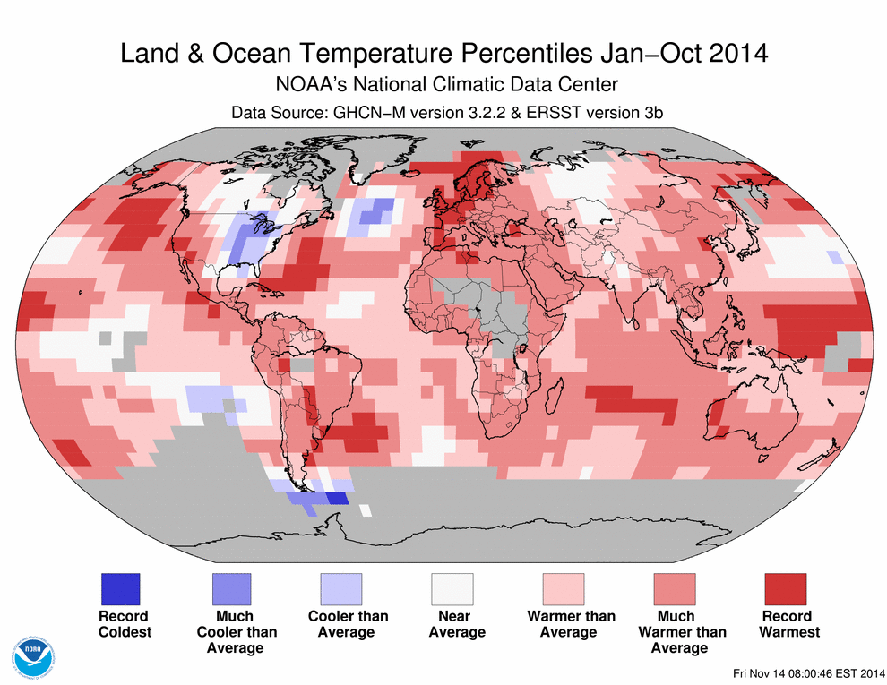
According to the US National Oceanic and Atmospheric Administration (NOAA) the first ten months of 2014 (January-October) were the warmest such period since record keeping began in 1880. Global land and ocean average surface temperature reached 0.68 °C above the 20th century average of 14.1°C. Making 2014 on track to become the warmest year on record. Record warmth for the year so far has been particularly notable across much of northern and western Europe, parts of far east Russia, and large areas of the northeastern and western equatorial Pacific Ocean.
Sweden was warmer than average during October, with the southern half of the country experiencing temperatures 2-4°C above their October averages (SMHI). On October 28, the daily temperature in Stockholm was 14.2°C, the highest daily average observed so late in the year since records began in 1756.
Northern Hemisphere is warming faster
Looking at historical records of Land and Ocean surface mean temperature anomalies we can see that the northern hemisphere is warming much faster, with some of the most rapid warming rates on Earth located in the Arctic, where sea and land ice is shrinking and thinning.
Changes in albedo (i.e. reflectivity) difference between the Arctic and Antarctic and global ocean currents contribute to the Northern Hemisphere’s rapid warming, according to researchers from Potsdam Institute for Climate Impact (Feulner et al. 2013). Currents transport heat away from southern waters and into the North Atlantic and North Pacific, helping to warm nearby land areas in the north even more. For example, the Gulf Stream, which carries heat from the tropics far into the North Atlantic, along the Scandinavian west coast (see map).
Temperatures in the Arctic have risen twice as fast as the rest of the world, a phenomenon known as Arctic amplification (Cohen et al. 2014). Scientists have linked the rapid rise in Arctic temperatures over the past two decades to weather extremes in the Northern Hemisphere such as heatwaves in the US and flooding in Europe (Coumou et al. 2014, Francis 2014). Rapid warming in the Arctic can have triggered changes to global wind patterns, which have brought extreme weather to lower latitudes. Extreme weather events have almost doubled over the last two decades. Now researchers think that this can be linked with unusual weather patterns in the upper atmosphere, influenced by warmer Arctic temperatures. They believe that the loss of sea ice in the Arctic may be contributing to the appearance of wide north-south swings in the high-altitude winds flowing globally west to east around the polar region, causing them to “get stuck” and amplified in a quasi-stationary pattern known as a “standing wave”. When interviewed by the Independent one of the researchers, Stefan Rahmstorf, said “Evidence for actual changes in planetary wave activity was so far not clear. But by knowing what patterns to look for, we have now found strong evidence for an increase in these resonance events” (Professor of Physics and co-chair of Earth System Analysis at Potsdam University). The possibility of a link between Arctic change and mid-latitude weather has spurred research activities that reveal three potential dynamical pathways: changes in storm tracks, the jet stream, and planetary waves and their associated energy propagation (Cohen et al. 2014).
Changes in precipitation
A study from Berkeley has projected that if emissions remain on their present upward trajectory, the average temperature difference between the two hemispheres could be about 1.6°C. This would be sufficient to alter tropical rainfall patterns, which could affect everything from rice cultivation in India to the health of the Amazonas Rainforest (Friedman et al. 2013). According to the authors, tropical rain bands that form near the equator where trade winds collide to build up thunderstorms may shift northward, drying out parts of the Southern Hemisphere, while causing more precipitation in the North.
.png)